Data shows impact of January storm on seafloor
Nor'easter moved part of artificial reef, new data shows
- January's storm combined huge waves over the course of several hours to produce a record-breaking high tide.
- University of Delaware researches have been monitoring how waves and currents alter the seafloor.
- There are 14 artificial reef sites in the Delaware Bay and coastal waters and an additional five reefs in the ocean.
Giant waves cut away at Delaware's ocean coast during a record-breaking nor'easter in January but offshore, the impact on the seafloor was even more dramatic.
The waves from the storm were powerful enough to peel away the tops of sunken subway cars on the state's Redbird Reef, an artificial reef 16 miles east of the Indian River Inlet, and turn a barge on the site.
"My jaw just immediately dropped," said Arthur Trembanis, an associate professor at the University of Delaware. "I said, 'That's really weird. That doesn't look like the orientation. I don't remember the barge having a north-west orientation."
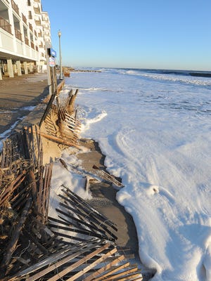
January's storm combined huge waves over the course of several hours to produce a record-breaking high tide at Lewes Breakwater Harbor and cause significant shoreline erosion from Lewes south to Fenwick Island.
At Rehoboth Beach, waves washed under the boardwalk at the city's north end and pounded the structure from the bottom up, lifting the decking and breaking the hurricane ties that held it in place. Dunes were swept away, and at Bethany and South Bethany, as much as one-third to one-half of the protective sand dune was chopped off leaving a 12- to 16-foot dropoff to the beach.
But the geologic change off shore was even more dramatic, Trembanis and his team of students found.
STORY: Delaware seeks $2.5 million in coastal disaster aid
STORY: For beach businesses, July Fourth is no holiday
Trembanis has been monitoring how waves and currents alter the seafloor, deep beneath the ocean surface. It is not, as some might think, protected from the surface waves. Instead, the seafloor is a dynamic place where surface waves can create sand ripples and scours. Wreck sites like the man-made Redbird Reef site make the perfect undersea laboratory where researchers can see how surface waves and currents impact the bottom.
Delaware officials started the Redbird reef site in 1996. It gets its name from the Redbird paint-schemed subway cars donated in 2001 by New York City Metropolitan Transportation Authority. State officials sank 619 of the obsolete subway cars. Each was 51 feet long by 9 feet wide and were used to create structure at the reef site. They later added a tugboat and a barge.
Jeff Tinsman, Delaware's Artificial Reef manager, said "We were hoping for a 20 to 25 year life expectancy" for the subway cars once they were added to the reef. This is the 15th year.
They were a huge game-changer for the reef site, which at the time it was developed was the farthest offshore. Initially, it was built using surplus military vehicles that had been cleaned for use on a reef, Tinsman said. But it was a large area and the sunken vehicles didn't create a large expanse of undersea habitat. It didn't get all that much use.
Once the cars were added, the rate of anglers fishing on the Redbird artificial reef site increased 50-fold, Tinsman said.
The structure on the formerly flat expanse of sand creates a unique habitat for fish. And even as the subway cars move and shift, the habitat evolves, he said.
For instance, the lower the profile of the cars, the more suitable they become for lobster, Tinsman said. That's because the crustaceans can back into openings that form in the remains of the cars.
Delaware has 14 artificial reef sites in the Delaware Bay and coastal waters and an additional five reefs in the ocean.
Trembanis and his team use high-tech tools and robots to map the seafloor, and they have been monitoring the changes at several sites including the Redbird Reef, since just before Hurricane Sandy in October 2012. The massive superstorm gave them an opportunity to get both before and after images of the bottom, and because their instruments were still in position, they could collect real-time data.
That information has allowed them to use data from nearby off-shore buoys that measure wave height and frequency to calculate what is happening on the seafloor.
Since Sandy, Delaware has experienced major nor'easters in October 2015 and in January.
Trembanis said each was slightly different, both from inshore and undersea impacts. Sandy was very powerful but of short duration. The October storm built over several days but was less intense, and the January storm was a hybrid of the two, lasting far longer than Sandy with offshore waves that exceeded the height of those in the superstorm, he said.
After Sandy, Trembanis and his team found dramatic changes at the reef site with subway cars turned and toppled on their sides.
In the October storm, the footprint from Sandy remained and there weren't significant changes, he said.
But the January storm altered the site again.
The edge of the barge had what looked like a plowed edge, Trembanis said. It almost looked like what your windshield would look like once your wipers pushed through slushy snow, he said.
"It was incredible," he said.
Trembanis and his team didn't have access to a research vessel to visit the site immediately after the January storm so he reached out to the National Oceanic and Atmospheric Administration, which had a survey vessel travelling between New York and Norfolk. That team agreed to run a bottom survey over the Redbird reef site and supplied Trembanis with the data.
Then, he and his team went out in March and confirmed that the barge had shifted.
"We saw fragments of subway cars. doorways, window jams, frames ... the tops were kind of peeled off and blown like some drifting tumbleweeds into the side of the barge," he said. "The barge itself is still intact. It's actually at the same height."
What the scientists see are ripples on the seafloor. They form a signature of storm events and tell the story of the wave-generated currents that move back and forth on the ocean bottom as the movement stirs up sediment and sand. You can see similar ripples on the beach after the tide recedes.

By studying these ripples, scientists get a clear picture of how storms impact the bottom and the ability to predict what will happen in future storms, said Carter DuVal, a University of Delaware oceanography doctoral student. He likens the ripples to a storm's fingerprint on the seafloor.
"Not only were we seeing a record of the storm, but of the most energetic part of the storm. This is very important for recording the storm's dynamics," DuVal said.
As the planet warms, many scientists expect coastal storms to increase in intensity, frequency and duration.
“For the Mid-Atlantic, nor’easters really are the dominant storm. What we’ve seen by looking back at the records is that the energy level conditions we measured during Hurricane Sandy have a two and a half to three-year recurrence interval,” Trembanis said.
STORY: Penguin declines linked to warming
STORY: New Killens Pond State Park slides unveiled
The January storm, for instance, shifted an old Navy barge that was sunk at the Redbird site 160 degrees, he said.
The work is part of a bigger study sponsored by the Office of Naval Research. The project is designed to look at the ecosystem and to create detailed maps of the seafloor at Redbird Reef. The site has been mapped every year since 2008 except in 2014.
The work has implications for people who live along the coast, too.
Trembanis said that to predict erosion, storm surge and the places where the ocean will wash over a beach, they must predict how a wave will change as it moves from the deep ocean just beyond the continental shelf to the shallower, nearshore waters that start about 60 miles off the Delaware coast.
“At practical levels, if we are going to appropriately predict and model how storms are going to behave, we need to be able to determine ripple parameters, such as wavelength and orientation to the shoreline, with accuracy," Trembanis said. "Until we began using a fingerprint algorithm, we didn’t have strong enough tools to do this."
Reach Molly Murray at (302) 463-3334 or mmurray@delawareonline.com. Follow her on Twitter @MollyMurraytnj.