Mid-Atlantic won't escape Irma's rains; wind damage is less certain, forecasters say
Days ahead of roaring ashore anywhere along the U.S. coast, Hurricane Irma has made one thing clear: It's coming for the Mid-Atlantic.
Irma's predicted track edged eastward from Tuesday to Wednesday, with its potential landfall falling on the east side of the Florida coast rather than the west.
Forecasters can't say with any certainty yet where it will land or how fierce its winds will be when it does so.
But as far as the Mid-Atlantic is concerned, heavy rains are all but a given at some point along the storm's path, said Mike Rusnak, a meteorologist with the National Weather Service's Wakefield, Virginia office. The region could begin seeing effects from the storm late Monday into early Tuesday next week.
Whether the monster Category 5 storm still has any punch left to its wind will depend on whether it stays to the west, losing its oomph over land, or veers east, sustaining strength over open water, Rusnak said.
READ MORE:Hurricane Irma: What we know now and where it's headed next
“Given the track, it’s definitely putting some rain down on the entire Mid-Atlantic region," he said. "Now, with the wind, a lot depends what happens over the next two or three days.”
A front is expected to steer Irma northward as it steams westward just north of the Cuban coast, he said. The timing of that turn will be crucial for Florida and points north.
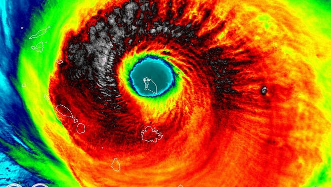
As of 2 p.m., Irma was spinning near the Caribbean island of St. Thomas with rarely seen ferocity. Its sustained winds were measured at 185 mph, matching the strength of the strongest hurricane to ever hit the U.S.: the 1935 Florida Keys storm.
Rusnak said his best advice for the Mid-Atlantic is to continue watching Irma's track and prepare for what could be a soggy and potentially windy blow. It will arrive along the eastern United States "one way or the other," he added.
Irma's unpredictability prompted mid-Atlantic officials Wednesday to urge residents to prepare for just about any outcome.
"(S)till need to monitor and make your preparations now," Wicomico Emergency Services said on its Facebook page. "Do you have an emergency plan?"
In addition to protecting human life, pets and livestock should be part of emergency plans, the Maryland Department of Agriculture said. Officials urged people to take their pets with them if they flee a storm's path; poultry and livestock should be moved to higher ground and housed in some type of shelter.
The University of Maryland Eastern Shore said it was monitoring the storm and would issue advisories over campus email and social media as the path becomes more certain.
MORE:How to donate locally to Hurricane Harvey victims
410-845-4630
On Twitter @Jeremy_Cox