Hurricane Irma: Delmarva should prepare now for possible impact
 Meg Ryan
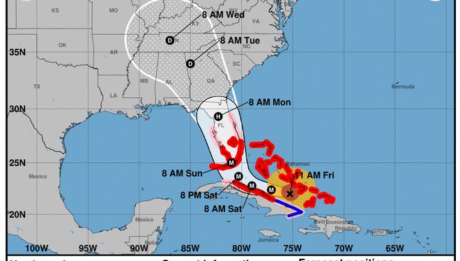
As Hurricane Irma gets closer to making landfall in Florida, the U.S. is preparing for what the super storm will do.
Delmarva residents should expect to see the effects late Monday, Sept. 11, with rainfall going into Tuesday, Sept. 12, said Alec Butner, a meteorologist at the National Weather Service in Wakefield, Virginia. While gusty winds of about 30 mph are expected, residents shouldn't worry about extreme weather conditions.
"Nothing tropical storm (or hurricane) force," he said.
On Sept. 7, the Maryland Emergency Management Agency urged residents to prepare now as Hurricane Irma impacts are still too early to predict and are being monitored.
“I urge all Marylanders to prepare now for the potential effects of Hurricane Irma," said Gov. Larry Hogan in a MEMA press release. "While we have the benefit of time, review your family emergency plans and ensure you have supplies on hand. As always, Maryland stands ready to support our friends and neighbors in states that will be dealing with the impacts from this major hurricane first.”
RELATED: Hurricane Irma: Where is the Category 4 storm now and where is it headed next?
MEMA is staying in contact with the National Weather Service, as well as, local emergency management offices and its state partners, according to the press release.
Instructed by MEMA, residents are suggested to prepare an emergency kit including items like: water, non-perishable food, flashlights, additional batteries, toiletries, important document copies and a radio that is battery-operated.
Those worried about being in an area that is flood-prone can check MEMA's website.
According to a National Hurricane Center Public Advisory, Hurricane Irma is now a Category 4 hurricane on the Saffir-Simpson Hurricane Wind Scale. Maximum winds are recorded at 150 mph. The storm is expected to stay a Category 4 as it makes its Florida landfall.
The eye of the storm is predicted to be around Cuba's north coast and the central Bahamas starting Friday, Sept. 8 and into Saturday, Sept. 9. The Southern Florida peninsula and the Florida Keys should brace for the eye starting Sunday morning, Sept. 10, according to the advisory.
Butner said Hurricane Irma's impact will be mostly to the southern U.S. After reaching Florida, the storm's path looks to head toward Georgia and the Tennessee, and Ohio valleys.
Hurricane Jose is now upgraded to a Category 4 hurricane, according to the National Hurricane Center. However, Butner said it's still too far away to predict what the U.S. can expect.
"A lot of uncertainty," he said.
On Twitter: @The_MegRyan