Beach strategies: Rebuild, retreat or relax
Just off Dewey Beach, the Dodge Island dredge boat mined a slurry of gray sand and sea water from the ocean floor, stockpiled it in a gigantic hopper and then moved close to shore so the sand could be shot onto the beach and smoothed to perfection before the weather warms.
This beach, and others from the curved sand spit at Cape Henlopen to the inlet at Ocean City, Maryland, are the multi-million dollar coastal tourism drivers for two states. Wide sandy beaches are the attraction. By comparison, the boardwalks, the restaurants, the back-bays water sports, the fishing charters, the arcades, even the classic Herschell-Spillman Carousel at Trimper's Rides in Ocean City, is like the tail on the dog that spins round and round.
These towns struggle to maintain their biggest attraction. And in the face of rising seas, uncertain federal funding for beach replenishment and now, a president who has said climate change is a "hoax," Delaware, Maryland and Virginia could soon be forced to compete for limited sand-pumping dollars against states with more political leverage.
Even a minor storm, like the one that rattled the coast Monday, had consequences on area beaches.
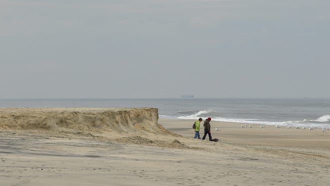
Sand earlier pumped by the Dodge Island shifted –– giving the previously smooth, flat, wide beach at Rehoboth a ledge with a sizable drop off.
A short drive south and east to Chincoteague, Virginia, a 1,000-car parking lot is underwater during most storms. Federal Wildlife officials plan to retreat from this site and move 1½ miles north where the beach is more stable. They don't have money yet for the project, which is estimated to cost between $12 and $15 million.
Farther south, there is a string of barrier islands owned largely by The Nature Conservancy. The strategy: Let nature take its course.
Experts say beach communities should work together to manage eroding shorelines.
"There is not anywhere near enough money to deal with existing projects," said Howard Marlowe, a Washington, D.C., lobbyist who specializes in coastal issues. Marlowe suggests coastal communities along Delaware, Maryland and Virginia's Atlantic Coast need to form regional plans for beach repair, coastal resilience and a response to the impacts of sea level rise. It would represent a new way of thinking about beaches and the approaches used to protect them.
No one is certain what President Donald Trump's approach will be to shorelines and beaches after describing climate change as a hoax during the campaign. According to The Guardian, Trump is poised to eliminate climate change research conducted by NASA as part of a crackdown on “politicized science.”
Delmarva has been the beneficiary of millions of dollars for beach replenishment, and the money has flowed regardless of the political leaning of the president or Congress.
Marlowe and others believe that, no matter what, there needs to be a new approach to shorelines.
"The reality is we can't hold every shoreline in place," said Rob Young, director of the Program for the Study of Developed Shorelines based at Western Carolina University, in the mountains of North Carolina. "We don't have the sand now ... and each community has their hotspots. Nobody's saying abandon the coast."
This week's storm reminds us just how vulnerable our beaches are. While much of the sand is just offshore in a sandbar and will likely return with calmer weather, the shoreline is always one storm away from disaster. And lately, those storms seem to be more frequent and furious.
While Monday's storm was minor, a year ago, on January 23, 2016, tides at Breakwater Harbor in Lewes broke a record set during the March Storm of 1962.
Three of the top 10 high tides at Lewes occurred this decade: Hurricane Irene in 2011; Hurricane Sandy in 2012 and the Jan. 23, 2016, nor'easter. Four of them were in the previous decade. And major storms like the Mother's Day nor'easter in 2008 and Nor'Ida in 2009 –– both of which packed a punch –– don't even make the list even though they caused significant beach erosion and flooding.
Preserving resort beaches
On the Dodge Island boat, the sand in the hopper diminishes by the minute as it is pumped onto shore.
Sand enough to fill 65,000 dump trucks was smoothed along the shoreline from Dewey to Rehoboth beach last month. This sand is like chemo to a cancer patient. It keeps the two resorts alive, at least for the 2017 season.
Without it, says Tony Pratt, Delaware's Shoreline and Waterway manager, the ocean would be lapping under Rehoboth's mile-long Boardwalk with every high tide. Even at low tide, there would be little space to plant a beach chair and umbrella.
Pratt knows this because the average erosion rate at Rehoboth Beach ranges from two to four feet a year. In 2006, when the state and federal government entered into a 50-year beach re-nourishment plan for the two municipalities, the beach at Rehoboth Avenue was about 25 feet wide. Take 10 years and multiply it by 3 feet a year and the beach, as we know it, would be gone at high tide. That doesn't include the significant sand losses from the strong nor'easter known as Nor'Ida in November 2009, Hurricane Irene in 2010, Hurricane Sandy in 2012 and a January 2016 nor'easter that cut away what little dunes were left after an October 2015 nor'easter.

The storm last January was so bad that waves cracked beams supporting the north end of the boardwalk, and the man-made dune was flattened. In the weeks that followed, the beach made a slow recovery with the help of state crews pushing sand from the water's edge to the high beach.
Pratt, who is president of the American Shore & Beach Preservation Association, said the beach is critical for economic development in cities like Rehoboth.
He points to what happened years ago in Atlantic City, New Jersey, when the beach was depleted and there were no casinos yet to draw tourists. Or to Miami Beach, which suffered prior to massive infusions of sand and a subsequent re-branding as a tourist mecca.
It creates a cascading effect, he said. The beach gets smaller and smaller and tourists start visiting other towns. Businesses shift from the trendy restaurants and high-end boutiques that Rehoboth visitors enjoy to places that cater to a crowd with less disposable income. Then stores and businesses stand vacant and property values decline, he said.
So for now, pumping sand on Rehoboth and Dewey Beach makes economic sense and is sustainable, at least for the near future. But in 30 or 50 years, the costs may outweigh the benefits, Pratt said.
Know when to flee
Farther south, where a bridge from Chincoteague, Virginia, carries summer visitors from the town to the beach at the Chincoteague National Wildlife Refuge, there is a different and equally pressing problem.
The beach is moving west and south at a rapid rate –– so fast, in fact, it makes what is happening in Rehoboth look like a race between the hare and the tortoise.
It takes billions of dollars to keep the nation's beaches from washing away, and it's not a lasting, long-term fix.
In a single year, the north end of Assateague Island, which starts just south of Ocean City Inlet and runs south until it reaches the hook at Toms Cove at Chincoteague, erodes on average of 30 feet each year.
Meanwhile, that hook is growing rapidly, gaining about 132 feet a year, according to a federal assessment of Atlantic Coastal Erosion rates from Maine to Virginia that was completed in 2011.
Standing in the way of this natural progression of sand west and south is a 1,000-car parking lot.
Since 2009, it's been moved three times and been scraped clear of sand and debris with just about every passing storm. It's nearing the end of the line. There is little space remaining for the beach and parking lot to migrate west.

When people drive in "they can sit in their car and see that ocean," said Kevin Sloan, manager at the 14,000-acre Chincoteague National Wildlife Refuge. "You have 360-degrees of water" view.
Easy access to the ocean is what makes the parking lot so vulnerable, Sloan said.
As in Rehoboth and Dewey, the beach here is an important tourism driver but refuge manager Sloan said the parking lot isn't sustainable and causes lots of problems. As the ocean overtakes it, chunks of asphalt churn in the surf and end up scattered along the beach.
The National Parks Service manages this recreational beach and they have been pushing up sand to build a dune to protect the lot.
But Sloan isn't convinced that is helping. In fact, he said, it may be doing more harm than good.
"When you stop over-wash you begin to get a narrower piece of land," he said. It may actually be decreasing the lifespan of the beach."
The plan now is to retreat –– move the parking lot 1½ miles north where the shoreline is more stable and allows the beach to migrate as the shoreline erodes and sea levels rise.
"It's not funded yet, but we're looking for funding," Sloan said of the estimated $12 million to $15 million project.
Let Mother Nature do her thing
There is a third beach management strategy on Delmarva, one practiced by The Nature Conservancy on the 14 barrier islands it owns or partially owns off Virginia's Eastern Shore.
"Our policy ... is to allow natural barrier island migration to occur," said Gwynn Crichton, senior scientist for The Nature Conservancy in Virginia.
Despite the fact that no one lives on these islands, this strategy, too, is controversial.
Wachapreague, "The Little City by the Sea," is nestled behind a vast salt marsh protected by Hog Island.
Cedar Island, once marketed as a remote and exclusive vacation get-a-way, is rapidly shifting shape, too. The high-end houses, built there in the 1980s are all gone.

Because people see climate change impacting nature so rapidly, the natural inclination is to want to do something, Crichton said.
"It can have all these unintended consequences," she said. The reality is that altering the natural process in a place like the barrier islands of Virginia could "perhaps make the inevitable happen a lot faster than it would have happened otherwise. Those islands will persist and remain viable" if they are left alone ... "There's nothing we can do, really, to fight Mother Nature."
Michael Fenster, the Stephen H. Watts professor of science at Randolph-Macon College in Virginia, has been studying the barrier islands off Virginia for years.
In fact, these islands are among the best studied anywhere on the Atlantic Coast.
The other hot zones for coastal erosion on Delmarva such as the north side of Indian River Inlet and the south side of Ocean City Inlet are largely man-made problems. Once a hurricane severed the south end of Ocean City from the north end of Assateague, local leaders asked that the opening be stabilized. Because the inlet is there, it blocks the flow of sand to Assateague with dramatic consequences.
The north end of Assateague has receded dramatically in the last 80 years. The same is true at the north side of Indian River Inlet.
But there are other factors, too, Fenster said.
There is the impact of waves, of tides, of storms. Some coastal geologists believe storms aren't necessarily bigger, but it may be getting stormier with a cumulative impact building over time. And there is the impact from sea level rise. Along the Delmarva Peninsula, sea level is rising faster than many other places because the land is also sinking.
Fenster said that from Assateague Island north, waves are the big player in erosion. But along the barrier islands, tides may be more critical in the way the islands are reshaping. There are also extensive salt marshes behind the islands and there likely is interplay between the two, he said.
The big question in the ongoing beach management debate is how sea level rise will play into the calculations.
The Nature Conservancy worked with scientists at Duke University and the University of North Carolina to model the network of barrier islands off the Virginia Coast. The model goes a step farther than Delaware's online Sea Level inundation tool. Delaware's tool uses a bathtub model which basically simulates how land would flood if water was poured on top like filling a basin.
The new tool developed for the Conservancy uses data collected by the Federal Emergency Management Agency and other sources to look at future flooding along with storm surge and sea level rise.
The goal, Crichton said, was to develop tools that could be used to plan for the future. As a conservation organization, scientists want to see how wildlife habitats might change over time.
But for the seaside communities, she added, the tools could help officials plan and adapt –– let planners see "how to make nature work for them."
Contact Molly Murray at (302) 463-3334 or mmurray@delawareonline.com. Follow her on Twitter @MollyMurraytnj.