The everyday tide of the future? Highest tides offer a 'dress rehearsal' for climate change
 Jeremy Cox
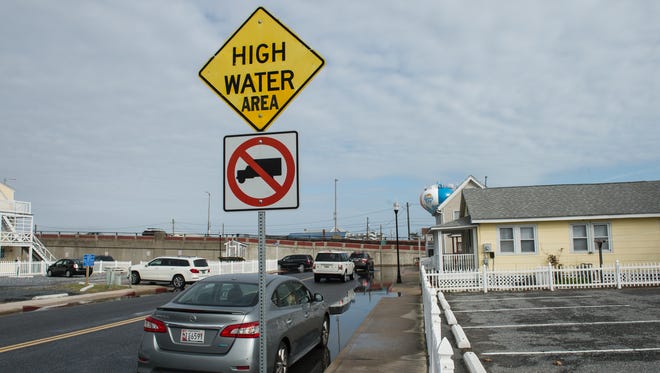
A woman shimmies along a concrete slab to avoid stepping in shin-deep water flooding the street in Ocean City. Her spirited conversation on her cellphone goes uninterrupted.
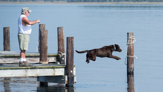
On the opposite side of the Delmarva Peninsula, a man plays fetch with a chocolate Labrador retriever named Gus outside a hunting shack "down neck" from Crisfield. He uses a crab buoy instead of a stick because it floats in the waters that have overflowed into the yard from Pocomoke Sound.
Water oozes upward between the planks of wood in the floor of a crab shanty on Jenkins Creek a little closer to Crisfield. The man who bought the property two days earlier shrugs and casts a yellow rubber worm into the water, hooking a rockfish before the ripples have vanished.
"It's not a big deal," Brady Stevens says, adding that the water drains as quickly as it arrives. Besides, "it's not like a house with a living room."
It's just a typical sunny Sunday on Delmarva but for one astronomical anomaly that, if only momentarily, binds the region's coastal residents and offers a disconcerting preview of the area's water-logged future.
It is the year's highest of high tides: the king tide.
Known in scientific circles as a perigean spring tide, it marks when the sun, moon and Earth align with one another to exert greater gravitational pull on the water. What makes the event stand out even more on the calendar is that it takes place when the moon's elliptical orbit brings it closest to Earth, adding to its gravitational punch.
King tides, in a word, are natural. But they give a glimpse of how an unnatural force — man-made climate change — might reshape the area's geography, scientists say.
"It's like a low-stakes dress rehearsal," said Derek Loftis, a researcher at the Virginia Institute of Marine Science. "It's really not dangerous conditions, but at the same time we know the city is going to flood."
Tidal flooding may be worse at other times, particularly during strong coastal storms. But weather conditions are usually too dismal for people to pay heed, said Roman Jesien, a scientist for the Berlin-based Maryland Coastal Bays Program.
A king tide, then, represents "a good wake-up call to folks to let them know what’s in store for us," he said.
The climate has changed
The extraordinary, though, is already ordinary.
A combination of rising seas and sinking land has caused water levels to climb by more than a foot over the past century on Delmarva. And there's no sign of stopping.
Sea level is projected to rise by 3.7 feet in the region by the end of the century, according to Maryland Commission on Climate Change. The commission's high-end estimate puts water levels at a dire 5.7-foot increase.
More:NASA teams with University of Delaware, VIMS to study climate impact on Wallops Island
Of the 91 communities nationwide experiencing repeated flooding from the normal ebb and flow of tides, a dozen are found on the Eastern Shore of Maryland, the Union of Concerned Scientists said in a report earlier this summer. A 13th, Chincoteague, lies just over the state line in Virginia.
The Washington, D.C.-based group defines "chronic inundation" as flooding that covers at least 10 percent of a community's usable land and happens 26 times a year, or once every other week.
The number of chronically inundated Maryland communities is expected to reach 39 by the end of the century, with the vast majority of those on the Shore, according to the study. The list includes Crisfield, Mount Vernon, Ocean City and Ocean Pines.
The amount of flooding within certain communities may increase as well. In Crisfield, for example, computer models suggest that surrounding waters will regularly overflow more than half of its land within two decades, the Union found.
In many cases, they are the very places with the least ability — financially and politically — to combat the coming tide, said Astrid Caldas, one of the report's authors.
“The issues they’re facing are immense, and they don’t have the resources," she said. "If you ask anybody there on the Eastern Shore, I’m pretty sure they’re going to tell you, 'No, we’re not ready at all.'"
Living in high water
But that's still in the future. Here in the present, on Nov. 5, the day of the king tide passes with little recognition and less alarm.
“We get so many high tides around here they kind of blend together," said Matt Whitbeck, a biologist with the Blackwater National Wildlife Refuge in flood-prone southern Dorchester County.
That sentiment pervades the region's coastal communities.
"This is because there's been an east wind and a full moon for a few days. It's just how it is," says Bruce Emely, a Crisfield native, as he watches the dog frolic with its human playmate in the inundated yard. "This is a high tide."
More:Crisfield's storm protection erodes as cost limits Sandy recovery
But he admits: "This is not average at all. Normally, at high tide, the water is just up against the rocks."

The gray rocks are the only indication that there exists any barrier between water and land at this moment. The cove, which bears one of Delmarva's most colorful geographic tags in Ape's Hole, has crept up a couple of steps to the porch and inundated part of the dock.
Emely is part of a group of friends that has gathered to prep for hunting season. A mixture of old country tunes and Motown wafts through the salt-tinged air as the men sip Coronas and weave cypress boughs into a quilt-like netting for their duck blind.
In his father's day, Emely says, an island once haunted the mouth of Ape's Hole. But it washed away long ago.
"Erosion," he explains. "That's the worst thing that's happened around here."
Like many folks in this conservative outpost, Emely puts more faith in his own memory and observations than the scientific consensus on global warming. The dark high-water marks along docks don't appear to be getting higher, suggesting that the sea is staying where it has always been, he says.
Two sheets of water have begun streaming across the winding gravel road that is the shack's only link to civilization. It's a few minutes before noon — still about an hour from high tide.
The tidal wave
The worst has already visited Ocean City for the day, and it wasn't too bad at all.
The tide, after all, amounts to a slow-moving wave. Ocean City, as the name implies, faces the ocean. So the "wave" will lap onto its shores long before it reaches communities on the Chesapeake Bay side of the land mass. (To get there, it must wind its way through the mouth of the bay and for miles up the main stem.)
High tide at the fishing pier is at 7:50 a.m. on this day. According to the National Oceanic and Atmospheric Administration, the Atlantic is sloshing ashore at a height roughly 1.5 feet above a normal high tide.
More:Cardin: $3M beach nourishment is a great investment for Ocean City
At the southern tip of the island, the grayish-green water breaks over the bracing of boulders. But it doesn't collect and doesn't wash over the nearby Ocean City Inlet parking lot, which is known to flood in the mildest of storms.
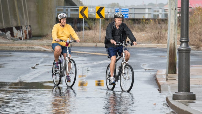
On the bayside within the roar of the Route 50 bridge, cars and SUVs must contend this morning with a few streets that have turned into skinny pools despite the dry weather. Some hesitate, but most plow forward as though the waters' sudden appearance were as unremarkable as the sunrise.
"Something to do with global warming"
The countdown to Crisfield's king tide is heading into its final minutes.
If any Delmarva community respects the power of nature, it's surely this one. Five years almost to the day earlier, Superstorm Sandy forced 5 feet of water onto the city's streets, damaging about one out of three homes.
For its part, the Union of Concerned Scientists is really concerned about Crisfield. The city rates no few than 23 mentions in the organization's 51-page report, titled "When Rising Seas Hit Home."
It and other low-lying Eastern Shore communities, according to the report, "already cope with disruptive flooding and can provide a glimpse into the conditions and decisions that neighboring communities will face in 20 years’ time."
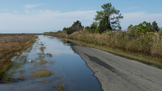
At 12:21 p.m., minnows splash in the submerged grass just off Calvary Drive. The two-lane road bisects marshes and pine forests from the city's harbor down toward Pocomoke Sound. The rising water had made it all but impassable, though, for several hundred yards of its length.
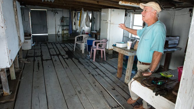
At the bridge over Jenkins Creek, Brady Stevens leans over the wooden railing of his newly purchased crab shanty and reels in fish after fish. That's no exaggeration; with virtually every cast comes a rockfish clamped to his hook.
His father, Craig, pulls up. Then a couple more friends. No one seems to mind that the creek has risen over the far edge of the dock and about a quarter of the floor area in the enclosed portion of the shanty.
The Stevens family owns a marine construction business. Working in this part of the country, they know the solution to rising water is to build ever higher.
Craig Stevens gestures in the distance toward the skeletal remains of a patch of pines. Saltwater marched into those uplands long ago and claimed them for its own, he says.
His voice drops to just above a murmur as if he were sharing a secret.
"It's something to do with global warming, wouldn't you say?" the elder Stevens asks rhetorically. "You see the changes. It takes a while to see it. I've seen it in my life. You see it in the marsh and the tree line, where it's dead."
The tide at this hour is very much alive. As the clock ticks past 1 p.m., a curiously normal thing happens inside the shanty. The bloated tide starts to recede, leaving a jagged line in the floor boards, like a memory of itself.
Craig Stevens points out this phenomenon, too: "It's just that quick."
The climate may take a lifetime or more to sort itself out. But the tide, even the king of all tides, is fleeting.
410-845-4630
On Twitter @Jeremy_Cox