New oyster reefs protect Assateague Bay from storms
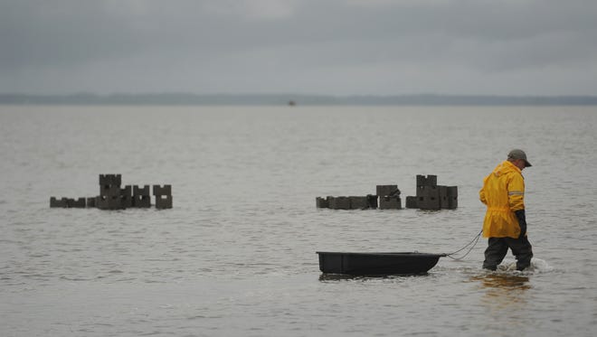
Nearly 20 volunteers waded into Assateague Bay last Friday, dragging and dropping thousands of concrete blocks into place to build “oyster castles.”
The concrete fortifications create instant habitat for oysters and are part of a larger initiative to protect the nation’s most vulnerable coasts.
“We’re going to take some of the punch out of waves with oyster reefs,” said Bo Lusk, Virginia Coastal Scientist with The Nature Conservancy.
The Conservancy teamed up with the U.S. Fish and Wildlife Service, Virginia Marine Resources Commission and other partners to put more than $1 million in grants to work in the wake of Hurricane Sandy.
The 2012 storm famous for washing away swaths of New Jersey’s Atlantic City Boardwalk had a lesser-known impact on Virginia’s Eastern Shore, Lusk said.
At Assateague, Sandy destroyed roads the oyster reef initiative aims to protect, including the access road along Assateague Bay and Beach Road, the main motorway more than 1 million visitors use to access the ocean each year.
Not only will the two-part Department of Interior grant fund more than 3,000 feet of the protective reefs, but it will also use the living structures to study how oyster reefs shield the shore from sea-level rise and strong storms.

Nature-based solutions
“Typically, if you want to protect your road, you build a seawall, you build a breakwater,” Lusk said.
But Chincoteague National Wildlife Refuge Project Leader Kevin Sloan said these traditional methods are “like Lays potato chips.”
“You don’t just do one resiliency project,” he said.
Nature-based solutions, such as oyster reefs, are different because they evolve over time.
READ: Learn the ins and outs of shucking oysters
Native oyster populations produce baby oysters, called spat, which swim and settle on the concrete castles and cover them with live oysters. At a growth rate of two or three inches each year, the oyster castles quickly become self-sustaining reefs, Lusk said.
“Oysters can grow upwards even faster than sea level is rising … whereas with a large offshore breakwater, we’d have to come back and add to it over time.”
As a bonus, oysters also filter the water and create habitat that supports commercial fisheries.As the reefs grow, they dampen waves, allowing sediment to gather behind them and the shoreline to grow. Scientists predict the slowed surf and stronger shore will make the coastline more resilient when storms hit.
“We know oysters are good for the environment,” Lusk said. “We’re getting a lot more bang for our buck using these reefs to protect our shoreline.”

Measuring success
All Hurricane Sandy projects have monitoring requirements, U.S. Fish and Wildlife Biologist Kevin Holcomb said.
On Assateague, The Nature Conservancy and Fish and Wildlife Service will monitor their oyster castles, determining how many oyster spat stick to them and how they grow, he said.
Partnering universities, such as the University of Virginia’s Virginia Coast Reserve Long Term Ecological Research Project, will track waves and the oysters’ success in slowing them, while environmental monitoring will tackle the health of the salt marsh, birds’ responses to the new reefs, water quality and the health of aquatic life nearby.
The data funnels into the Coastal Resiliency web application, which helps governments, agencies, businesses and homeowners see the effects of sea-level rise, said Gwynn Crichton, senior project scientist at The Nature Conservancy.
“We’re out doing these experimental, natural shoreline solutions to see how effective they are,” she said. “We’re putting these reefs in the water, we’re examining these reefs, and we’re taking that data back to the app.”
The Eastern Shore is Virginia’s first area to become part of the nation-wide mapping project, which shows flooding and sea-level rise under different scenarios and where marshes and other wetlands will likely be in the future.
A group effort
Volunteers have dipped and waded through Assateague Bay and Tom’s Cove several times over the last two months to get the oyster castles in place.
Some traveled hours to put the finishing touches on more than 2,000 feet of the living strongholds last week on Friday, May 6.
“There aren’t too many places like this left,” said Colin Williamson, who drove from central Pennsylvania to donate his time. “When you get the chance (to help), you just have to jump at it.”
Lou Hinds, the former Chincoteague refuge manager who saw Sandy’s impact firsthand, also came out to help.
“We knew we had a problem, and we know we have to get something done,” Hinds said.
After landing the grant, stabilizing and rebuilding the wrecked roads, and laying more than two acres of “shell plant” — crushed oyster shells that also encourage shellfish growth — “here we are finally getting the last parts of this project done,” Hinds said, “and it’s one of the best parts.”
Volunteers plan to finish building the nearly 3,500 feet of oyster castles in the two Assateague sites May 18.
Those who don’t see them putting the final touches on the seven-foot-wide castles can catch a glimpse of their handiwork lining the right side of Beach Road, on the drive to Assateague’s beach, during lower tides.
To see the Coastal Resiliency web tool that will use data from the oyster reefs, visit www.coastalresilience.org.