Hermine prompts 'limited' state of emergency
Wind and heavy rain already battered the Delaware coast Saturday, but it didn't keep people away, even as The National Weather Service posted a Tropical Storm Warning for all of Delaware.
Gov. Jack Markell announced a limited state of emergency for Sussex County starting at 5 p.m. Saturday. It allows public safety, emergency response and transportation officials to pre-position staff and equipment in areas expected to be hardest hit by Tropical Storm Hermine, as well as place resources in areas where the worst of the flooding is anticipated.
The governor's order doesn't limit driving and no evacuation orders are anticipated at this time, but state officials are closely monitoring the storm, said Jason Miller, a spokesman for Markell.
As much as six inches of rain could fall between Saturday and Monday in Sussex County, and there could be major flooding along the coast, into Delaware Bay and up the Delaware River into Wilmington and Philadelphia, according to forecasters with the National Weather Service at Mt. Holly, New Jersey.
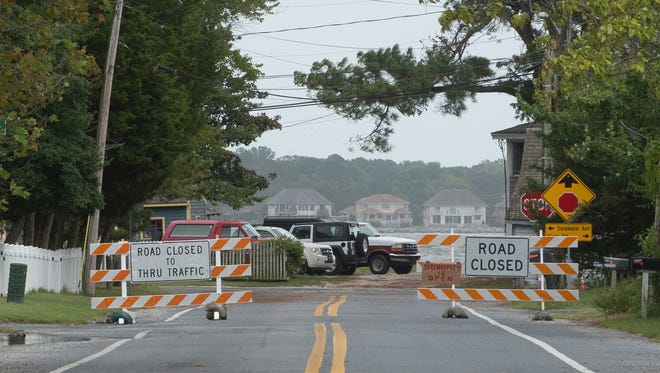
The Governor's limited state of emergency clears the way for emergency crews to close roadways and take other safety precautions if needed. In some areas, road closures were already necessary at high tide.
Preparing for the worst
Many coastal residents used Saturday to prepare for high winds from Tropical Storm Hermine, among them members of the Bowers Volunteer Fire Company.
Chief Phil Pennington and about 10 members of the department took time away from checking equipment and preparing the boats in their fleet for the worst to take part in a county-wide conference call. Pennington said that’s the protocol when inclement weather is forecast.

“Today, we were on the line with all of the chiefs in Kent County,” said Pennington, who is in his 10th year as chief. “On Sunday, it will just involve the chiefs in towns along the (Delaware) bay.”
Much of the preparation involved making sure the motors on the department’s 14-foot jon boat and 32-foot Viking were ready and all the equipment was aboard should the boats be called into action.
Another task involved surveying the roads closest to the St. Jones River and the bay to see if flooding had begun to occur. Saturday afternoon, some standing water remained from the last high tide, but none that caused concern.
At Kitts Hummock, high tide this morning crept close to, but did not overtake, the dunes on its public beach.
“Right now it’s just a waiting game,” said Pennington, who has been with the Bowers Volunteer Fire Company since 1978. “We’re here today to get prepared. We’ll have crews here at 8 a.m. (Sunday) to wait it out. Storms are unpredictable, but we’ll be ready.”
Bowers Beach firefighter Buddy Jackson says when the water tops the dunes near the beach, flooding in town will immediately follow.
A lot of the town's residents are new, he said, and may not know what's coming, even though the town has flooded before.
It depends on which direction the wind is coming from, he said.
"Anything out of the east, northeast, east and southeast. The worst is northeast, cause that keeps the tide in it doesn't allow the marshes or the tide or anything to drain out," he said.
An uncertain forecast
As of Saturday afternoon, Hermine was moving east at eight miles per hour off the coast of North Carolina's Outer Banks. It had winds of 68 miles per hour. The latest storm track shows Hermine continuing a northeast track parallel to the coast and regaining Hurricane strength with winds of 75 miles per hour around 8 p.m. Sunday when is it expected to be off the Maryland-Delaware coast. The exact forecast path is still uncertain. Weather service forecasters say the worst of the wind, waves and tides could be Sunday night and Monday morning.

STORY: Why you should avoid the ocean after it rains
STORY: Hermine's path moves closer to Delaware coastline
In the meantime, the weather service forecasters say peak winds of 30 to 40 miles per hour with gusts up to 50 mph are possible, and they are warning that flooding could cause problems in low areas. The storm could still stall just off the Delaware or New Jersey Coast before heading out to sea. That could make rain and flooding worse because the storm, with powerful waves or 20-feet or more, will pound away at the beaches and water will pile up in estuaries like Delaware's Inland Bays.
In Oak Orchard, the Saturday high tide already sent water into some streets and covered boat docks and many residents there were preparing for it to get much worse.
This was Jeremy Mott's fourth flood in 12 months.
"The last flood ( in January) we lost everything that wasn't hanging on the wall," he said.
On Saturday, he took a shovel, walked up the street and made sure the storm drain was clear of debris and mud. Inside his small, Indian River Bayfront home, he stacked his belongings to protect them from flood waters.
The house that he lives in has been through so many floods that the pine floors are already warped.
Brooke Lloyd has lived in Oak Orchard for a decade.
"I've been here long enough to just wait it out," she said.
When it gets really bad, she said, there will be 2 1/2 to 3 feet of water covering her front yard and she won't be able to go anywhere, she said.
"My whole front yard is nothing. . . . but water," she said.

Finding time to relax
Over at Cindy Battles' bayfront cottage, a party was in full swing.
It was David Harper's 60th birthday party and one of his sons had flown in from California.
They had the corn hole boards out and there was plenty of food. The rain held off in the afternoon.
Back in January, the whole front yard at the two cottages was covered in mud, and over the last several months, Battles and Harper worked hard to fix up their two cottages, bring in sand and plant sod.
But flooding is still an issue.
With the high tide on Saturday, water started to creep under the sliding glass door, Battles said. "I have towels in front of it," she said.
And it's not just the water that's a concern.
Following the January nor'easter "we have three inches of mud in both houses," she said.
Meanwhile, along Delaware Bay, the forecast didn't stop kids at Bowers Beach from playing in the ocean Saturday.
And with the Labor Day holiday weekend in full swing, traffic on coastal Del. 1 was as heavy as any other busy summer weekend and it looked like Black Friday in the parking lots at the outlet stores.

Rehoboth's Beach and boardwalk were a primo destination with folks, hair soaked to skulls, rain slickers billowing in the wind, striking their best Meteorologist Jim Cantore pose for the family selfie.
Some, like Kris Helm, of Reisterstown, Maryland, took it a step further. She went 'live' to friends and family from the beach in Rehoboth.
It was, she said, an instant sensation with dozens of hearts and likes.
"People get to see it as it is happening," she said.
Helm and friend Tom Troy, of Worcester, Massachusetts, are used to New England-style weather.
"This is like a spring day," she said.
The storm continues
The weather service says there remains some uncertainty with the track of Hermine Sunday through Monday, but flooding in the Delaware Bay and River could cause problems north to Wilmington and Philadelphia. The worst of the flooding is supposed to coincide with the Monday morning high tide. One reason for the concern is the storm is expected to slow and meander and prolong the storm impacts which will compound with each successive high tide. As much as 6 inches of rain could fall over the next several days. Coastal flooding may continue into Tuesday.
Along the ocean coast, the weather service says significant beach erosion is expected because of the size of the waves and the length of the event. Strongest winds are expected Sunday into Monday, the weather service said.
But during the morning high tide in Rehoboth Beach, just before 10 a.m., there were no problems and hundreds of people came out to see the big waves crashing onto the beach.
Roger Nisewarner and Bob Peffer, of Harrisburg, Pennsylvania, stood under the awning of the Candy Kitchen just off the boardwalk.
They have a summer house in Rehoboth and would have been here storm or not. This is not their first experience with a major storm in Rehoboth.
"I thought the nor'easter was worse," in January, Nisewarner said. "That's when it did so much destruction" at the north end of the boardwalk.
Reach Molly Murray at (302) 463-3334 or mmurray@delawareonline.com. Follow her on Twitter @MollyMurraytnj.