Hermine tracks north, but impact could linger for days
Tropical Storm Hermine is now hundreds of miles off shore, and Sussex County emergency officials believe the worst we can expect are big waves, rip currents and minor to moderate coastal flooding at high tide.
A tropical storm warning remains in effect for the Delaware Bay.
“This is certainly a better outcome given the forecasts leading up to today. But just because the sun is shining doesn’t mean our guard should go down,” Sussex County Emergency Operations Center Director Joseph L. Thomas said. “Forecasts can change quickly, so the public should keep an eye on Hermine until it pulls away for good or dissipates.”
Low-lying areas like Long Neck, Broadkill and Prime Hook beaches, which typically flood during storms, remain vulnerable to flooding through the Monday morning high tide, where water levels 1 to 3 feet above the normal high-tide levels are anticipated, county emergency officials said.
Still, the impacts of the storm could linger for days with large swells and rip currents along the ocean coast.
There has been some beach erosion already, but mostly, the waves have rolled up over the berm and haven't damaged the dunes that survived a nor'easter back in January. Blowing sand did cover a large section of Rehoboth's Boardwalk around Grenoble Place.
The big threat is rip currents.
That prompted Rehoboth Beach Patrol Capt. Kent Buckson to keep the beach open for sunbathing and other activities but close the ocean to swimming and other water activities.
Buckson said the waves are just too big and the rip currents too strong to risk allowing people in the water. Adults might be able to hang in there until guards reach them and help, but young children would quickly be lost in the churning surf, he said.
"We've got a full staff," Buckson said. "We want to at least have the beach open."

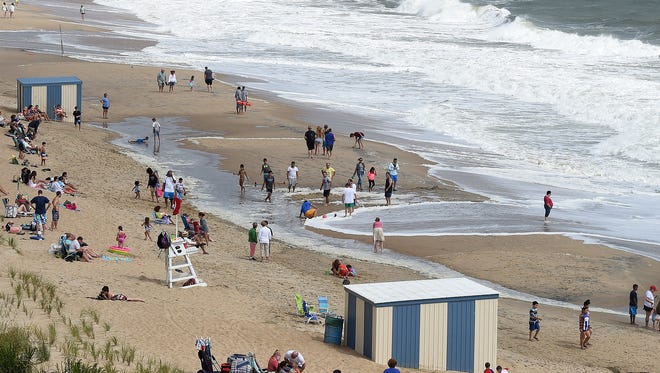
At Sunday morning's high tide, waves did roll up the beach and leave very little dry sand in many places, but hundreds of people set up chairs to take advantage of the sunny, breezy beach day.
The north section of Rehoboth's beach was badly damaged during a January nor'easter, and there is little dune left to protect the boardwalk or the buildings behind it. A sand pumping project is planned for Rehoboth and Dewey beaches later this year.
Dick Bawcomber, of Alexandria, Virginia, sat on one of the boardwalk benches and watched the waves and the people.
"What storm?" he said. "It's very pleasant."
He joked that the worst of the storm is likely over because his wife already started washing the salt spray off the windows of their condo in the Henlopen.
In Bowers Beach, fire chief Phil Pennington said he and the other shoreline chiefs received a text saying that the storm was heading north and the worst of it seemed to be over.
"We're still anticipating some water, but nothing like we originally thought," he said. "Everything is getting back to normal, but we're still armed and ready in case something changes."
Forecasters have revised their rainfall forecast to less than 1 additional inch for the region. A tropical storm warning remains in effect. The Sussex County Emergency Operations Center was to start operations at noon on Sunday, but because of the storm's new path, will instead simply monitor the storm system in case it turns again toward the coast.
STORY: Hermine prompts 'limited' state of emergency
VIDEO: Welcome to Rehoboth, tips from the locals
As of 11 p.m. Sunday, Hermine had sustained winds of 70 miles per hour. It was 325 miles southeast of the eastern tip of Long Island, New York, and was moving north-northeast at 3 mph.
Sunday there were clear, sunny skies at Delaware's coast and winds had dropped considerably. The peak wind gust at the Rehoboth Beach boardwalk on Saturday was 35.7 miles per hour. Sunday, the peak was 21.5 with maximum sustained winds of 17.1, according to the University of Delaware Environmental Observing Center. Less than a half-inch of rain fell Saturday at Rehoboth.
Thousands of people from Lewes to Indian River Inlet visited beaches – some to see the power of the massive waves and others to take in a sunny, cooler-than-normal beach day.
Mike Seidel, a Weather Channel meteorologist, was doing a live broadcast from the beach in Rehoboth on Sunday morning.
Meanwhile, Sally and Mark Lavelle of Minneapolis took advantage of every minute of beach time.
"We're here and making the best of it," Sally Lavelle said.
Even Saturday, when it was spitting rain and blustery, most vacationers still walked around outside.
"It was just windy," she said. "As long as there is sun and a beach, we'll be here."
Mark Lavelle said it was all about the beach and the holiday weekend.
"You can't take us away from the beach on Labor Day," he said.

Down at Indian River Inlet, the beach was still open and dozens of thrill seekers brought surf and boogies boards out into the churning water.
Among them was Eric Grottaus of Cincinnati.
When he learned about Tropical Storm Hermine, he left his home Friday and drove all night to experience the waves. It was a 12-hour trip, he said.
He normally surfs the Great Lakes, and the waves can be very large there, he said.
But this was a completely different experience, he said.
"They are pretty chaotic," he said. "It's brutal. It's hard getting out" through the breaking waves. … I certainly got my money's worth."
Reach Molly Murray at (302) 463-3334 or mmurray@delawareonline.com. Follow her on Twitter @MollyMurraytnj.